
The Fishermen’s Trail Portugal in Detail
The Fishermen’s Trail Portugal links Porto Covo to Lagos over 226 kilometres entirely along the coast. It is the coastal route of the Rota Vicentina network, fully marked and suitable for self guided hiking.
What sets it apart from other major European hiking routes: it almost never leaves the sea. You walk on dirt and sandy paths along cliff edges, across beaches, and along estuaries. No roads, no towns to cross, very little tarmac.
The 13 Stages of the Fishermen’s Trail Portugal
The 13 Stages of the Fishermen’s Trail Portugal
The full route is covered in 13 stages. Distances range from 7 to 22 km per day.
Stage 1: Porto Covo to Vila Nova de Milfontes
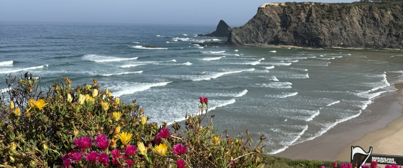
22 km. The first stage is the longest. It sets the tone: open cliffs, Atlantic wind, deserted beaches, almost no infrastructure between the two villages.
Stage 2: Vila Nova de Milfontes to Almograve
16 km. The trail follows the Mira estuary before returning to the coast. Vila Nova de Milfontes is the liveliest village in the Alentejo section.
Stage 3: Almograve to Zambujeira do Mar
19 km. Open landscape, low cliffs, passing Cavaleiro beach. Zambujeira is a small surfers’ village perched on the cliff edge.
Stage 4: Zambujeira do Mar to Odeceixe
17 km. The most inland stage of the coastal route. The trail follows the Seixe river valley up to Odeceixe, a village perched on the border between the Alentejo and the Algarve.
Stage 5: Odeceixe to Aljezur
21 km. Back on the coast after Odeceixe. Passing Amoreira beach and the Aljezur estuary. Aljezur marks the official entrance into the Algarve.
Stage 6: Aljezur to Arrifana
14 km. One of the most spectacular stages. Arrifana is a fishing village perched on a cliff with a sweeping view over the ocean, one of the most iconic images of the Rota Vicentina.
Stage 7: Arrifana to Carrapateira
18 km. The trail alternates between cliffs and beaches. Passing Amoreira beach and Monte Clérigo.
Stage 8: Carrapateira to Vila do Bispo
16 km. Bordeira beach, 3 km long, is one of the most beautiful stretches of the whole route. The trail then climbs back inland towards Vila do Bispo.
Stage 9: Vila do Bispo to Sagres
18 km. The trail descends towards Cape St. Vincent, the southwesternmost point of mainland Europe. Sagres is the pivotal stage between the Atlantic coast and the leeward coast.
Stage 10: Sagres to Salema
20 km. The landscape changes after Sagres. The coast becomes more sheltered, the waters calmer. The first stage on the Algarve’s Barlavento coast.
Stage 11: Salema to Burgau
12 km. A short stage, ideal for recovering after the previous long days. Burgau is a very well preserved fishing village.
Stage 12: Burgau to Luz
10 km. Cliffs and coves. Luz is a quiet little seaside resort with a beautiful beach.
Stage 13: Luz to Lagos
7 km. The final stage, short and easy. Arrival in Lagos, a historic town and the endpoint of the Fishermen’s Trail.
Choosing Your Section of the Fishermen’s Trail
You may not have the time to walk all 226 km. Here’s how to choose your section.
The Full Trail (Porto Covo to Lagos, 13 to 14 days) For hikers who want to experience the entire trail, from the wildest part of the Alentejo all the way to the Algarve. Requires good stamina over the full duration.
The Alentejo Section (Porto Covo to Aljezur, 7 to 8 days) The northern part, the rawest stretch. Long stages, little infrastructure, deserted beaches. For hikers looking for solitude and wide open space.
The Algarve Section (Aljezur to Lagos, 6 to 7 days) The southern part, less than 2 hours from Faro. Sculpted cliffs, Cape St. Vincent, lively villages. Ideal for a first stay on the Fishermen’s Trail.
Preparing for the Fishermen’s Trail Portugal
The Fishermen’s Trail presents no technical difficulty. There are no exposed sections, no climbing, no snow. But repeating stages over several days does require real preparation.
Specific points to watch on this trail:
Sand. Part of the stages are walked on soft sand, especially in the Alentejo. It is more tiring than packed earth. Bring light trail shoes rather than heavy hiking boots.
Sun exposure. The trail follows the coast with little shade for long stretches. Outside spring and autumn, the heat can become intense from mid morning onward. Start early.
Distance. The Alentejo stages reach 21 to 22 km. Before you go, train with at least 3 to 4 outings of 18 to 20 km carrying a backpack, ideally on varied terrain.
Wind. The Atlantic coast is exposed. Bring a windbreaker even in summer.
Frequently Asked Questions about the Fishermen’s Trail Portugal
Can the trail be done by bike? No. The Fishermen’s Trail is reserved for hikers on foot. The beach sections and narrow coastal paths are not suitable for cycling. For cycling on the Rota Vicentina, the Historical Way is the appropriate route.
Is there drinking water along the trail? Water points are scarce between villages, especially in the Alentejo. Your roadbook indicates supply points for each stage. We recommend setting off with at least 2 litres of water each morning.
Can you combine the Fishermen’s Trail and the Historical Way? Yes. Some stages allow you to switch from one to the other. We design combined itineraries on request, particularly for the full 14 day route.
Is the trail passable after heavy rain? Most stages remain passable. Some sections near estuaries can flood after heavy winter rain. We will let you know in real time from Faro if a stage becomes a problem.
Is there phone signal on the trail? Signal is good across most of the route, including in the Alentejo. There may be a few isolated stretches without signal. Our WhatsApp number remains reachable as soon as you have signal again.